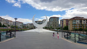
Yeşilyurt (Malatya)
Yeşilyurt is a central district of Malatya province in the west of the Eastern Anatolia Region. It is surrounded by Battalgazi in the east, Akçadağ and Doğanşehir in the west, Çelikhan and Adıyaman provinces in the south, and Yazıhan district in the north. With the amendment made to the metropolitan law in November 2012, Malatya became a metropolitan city and Yeşilyurt became the central district. Since archaeological excavations and surface surveys have not been carried out in the area where the district is located, there is no definitive information about its ancient history. However, since it is close to the city center and is a suburb of it, it is possible that they shared the same history. However, Byzantine ruins dating back to the 8th and 9th centuries found in Kaletepe show that there were some buildings here that were police stations during the Byzantine period. Apart from this, the name of the district is not mentioned in historical sources. This settlement, which was called Çırmıktı during the Ottoman period, took the name of İsmet Pasha after the proclamation of the Republic, and was turned into a district with İsmetpaşa as its center in 1957. Taşhoron Church is located in this district. Part of the district's territory, which forms the western part of Malatya center, consists of mountainous areas, the surface area of the district is 954.6 km². The southern part of the district is rugged by the Malatya Mountains, which are an extension of the Southeastern Taurus Mountains. The highest point of the Malatya Mountains is Şillan Hill, reaching 2,545 meters in Beydağı. The northern part of the district is within the extension of the Malatya Plain. The district's lands are irrigated by Beyler Stream (Derme Stream), which originates from outside.


Leave Your Comments